Using Translation

The County of San Mateo has added a translation feature developed by Google Translate to assist web visitors in understanding information on this website in a variety of foreign languages. Please be aware that Google Translate, a free third party service which the County does not control, provides automated computer translations that may not give you an exact translation. The County cannot guarantee the accuracy of translations through Google Translate so translations should not be considered exact and only used as a rough guide. Anyone relying on information obtained from Google Translate does so at his or her own risk. The County disclaims and will not accept any liability for damages or losses of any kind caused by the use of the Google Translate feature.

Author: Karen Wang

City of Pasadena, CA: the Shift to VMT for Transportation Impact Analysis

Overview

The City of Pasadena became the first city in California to implement the provisions of SB 743, a landmark piece of legislation that shifts emphasis of transportation impact analysis away from Level of Service (LOS) and toward vehicle miles of travel (VMT) projected for proposed development projects. Prior to making this shift, Pasadena staff conducted an extensive stakeholder outreach and education effort over a five-year period, including workshops for decision makers.  The result is an exemplary outreach process and a sophisticated set of procedures for evaluating the transportation impact of proposed new development.

As a result of this effort, the City of Pasadena developed Transportation Impact Analysis: Current Practice and Guidelines which provides guidance on the effects of development projects on the city’s multimodal transportation system, and on livability and mobility for all stakeholders within the city. Pasadena uses a transportation simulation and forecasting computer model to analyze potential transportation and land use changes. This multimodal travel model focuses on local context without the one-size fits all rules that are used in many communities.

There are established thresholds for each type of project proposal that triggers a different level of review. The primary measures used to identify these different review levels are the number of housing units for residential use and the gross floor area for commercial developments. Using these measures, the City determines if a project location warrants special consideration to exempt or impose a review based on VMT and transportation demand management (TDM). VMT-based thresholds from the California Environmental Quality Act (CEQA) are incorporated into the development review with additional Pasadena-specific measures. These thresholds represent allowable limits to projected increases in motor vehicle travel due to new development projects.

Policies and Ordinances that Contributed to Success

The City of Pasadena has a suite of policies and ordinances that support and enable a shift in transportation impact analysis away from LOS and toward VMT. The City’s Trip Reduction Ordinance mandates developer provision of TDM plans, programs, and facilities that may include public transit subsidies, vanpools, alternative work hours, paid parking for employees, reduced parking costs for vanpools and carpools, bicycle parking, bikeway linkages, public transit facilities, and an employee TDM coordinator. The City of Pasadena Traffic Reduction and Transportation Improvement Fees provide funds from new development and redevelopment projects for investments in the City’s pedestrian and bicycle networks and increased service on the Pasadena Transit System bus routes. The Pasadena General Plan Land Use and Mobility Elements encourage transit-oriented and pedestrian-friendly growth, guide the management of multimodal travel corridors, encourage non-auto travel, support community livability, and protect neighborhoods from the impacts of automobile use. Pasadena’s Complete Streets Program implements AB 1358 (the Complete Streets Act) within the city to better accommodate pedestrians and bicyclists on city streets as well as to preserve community livability.

Challenges and Lessons Learned

The City of Pasadena has been deliberate in its outreach to stakeholders, including residents, developers, and policy-makers. There were five years of outreach and deliberation prior to re-structuring the City’s transportation impact analysis policy and procedures. Problems, issues, and objectives were discussed in this public process. Pasadena has also invested resources and time in developing sophisticated analytical tools and staff capability to use these tools effectively. The Pasadena Travel Demand Forecasting (TDF) model enables City staff to estimate local transportation impacts relatively easily. The combination of public engagement, a context-sensitive approach, sophisticated tools, and a highly capable staff has allowed Pasadena to successfully reform the transportation impact analysis of new development and redevelopment.
King County: Strategies for Right Sizing Parking

Overview

The King County Right Size Parking (RSP) project, funded by a three-year grant from the Federal Highway Administration’s Value Pricing Pilot Program, assembled local information on multi-family residential parking demand to guide parking supply and management decisions. The objectives of the project were to:

  • Support economic development by reducing barriers to building mixed-use, multi-family residential developments in urban centers near transit;
  • Reduce housing costs as well as household monthly expenditures, allowing a wider market demographic to participate in the urban infill housing market;
  • Encourage transit use, rideshare, bicycling and walking; and
  • Reduce vehicle miles traveled (VMT) and greenhouse gases (GHG) emissions.

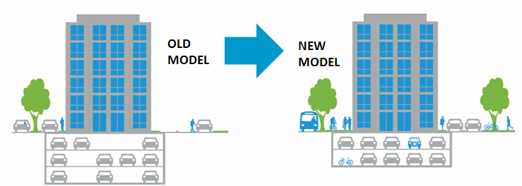
RSP research found on average that more than 40% of parking spaces went unused, often in walkable locations with nearby shops, stores, and restaurants and access to public transit.  The report of research findings noted that construction of parking in multi-family projects costs $20,000 to $40,000 per stall, which impacts rental prices. Based on this research, the RSP Project produced a Technical Policy Memorandum summarizing known barriers and potential solutions for RSP. This included a Right Size Parking Model Code that supports housing affordability and neighborhood walkability based on the RSP Project data and a RSP web-based Calculator which provides context-sensitive information on parking demand. The project also provides resources for developers – a Multi-family Parking Strategies Toolkit to help developers and property managers to better manage parking supply in multifamily buildings, and a Parking Requirements and Utilization Gap Analysis that identified misaligned parking requirements.

King City Model Transformations

RSP Calculator:

The RSP Calculator was developed by King County Metro, the transportation authority for the County, with support from the Center for Neighborhood Technology and the Urban Land Institute Northwest. It can estimate parking usage for different types of multifamily developments based on building type, location, unit and parking pricing, and proximity to transit and job locations. Additionally, the tool automatically calculates and displays parking utilization estimates for parking pricing bundled with or unbundled from rent, and 100% affordable units or no affordable units.

Parking Model Code:

The RSP Model Code project encourages local jurisdictions to match their parking supply to the actual demand. The model parking code is comprised of two approaches: market-based and context-based. In the market-based approach, there are no minimum parking requirements; rather, the market determines the amount of parking. This approach most effectively matches parking supply with parking demand so that developers are not forced to build more parking than is needed.

With the context-based approach, minimums are set based on the unique context and characteristics of a given project. The process has two steps. First, a generalized place type and associated base parking minimum is assigned. The proposed types are urban core, mixed-use center, and suburban commercial/residential neighborhood. Second, a series of adjustments are applied to that base minimum to account for specific building and contextual features, such as housing unit type, resident characteristics, transportation alternatives, off-street parking management, and parking stall substitutions.

Challenges and Lessons Learned

Having robust, accurate data from the local jurisdiction is crucial to developing the RSP calculator. King County focused on multi-family housing and collected data in the middle of the night from multi-family projects to ensure accuracy. King County has now updated the calculator due to the substantial growth in the county that is seen as continuing and changing land use. The key policy implication from the RSP project is that there is generally an oversupply of parking. Reducing parking requirements encourages greater transit use and enables more frequent transit service.

Despite the data demonstrating that parking is typically overbuilt, localities may still face resistance to reform. For example, the City of Kirkwood faced local opposition when they considered amending their parking requirements. Another challenge is educating developers and lenders about actual parking needs, since many still believe that they must supply additional parking on site in order to market their projects to prospective residents.

Mountain View, CA: Applying TOD Principles to Revitalize Auto-oriented Corridors

Overview

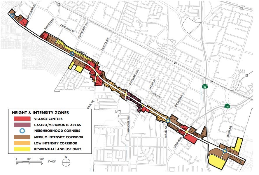
The City of Mountain View El Camino Real Precise Plan covers 287 acres and extends the entire 3.9-mile length of El Camino Real in the City, including some adjacent parcels. The Precise Plan, adopted on November 17, 2014, implements the City’s 2030 General Plan vision for the El Camino Real Corridor as a revitalized grand boulevard. The El Camino Real Precise Plan represents a unique application of the transit oriented development (TOD) concept to a linear auto-oriented transportation corridor. Instead of concentrating development around a single transit station, it creates a series of tiered developments within the corridor focused around transit and pedestrian activity centers, with higher intensity around bus stops in the Village Centers. It also includes neighborhood-serving retail at other intersections, as well as additional higher-density housing and some mixed uses provided in between with appropriate transitions to protect adjoining residential areas.

The Precise Plan supports the Grand Boulevard Initiative (GBI), a collaboration between 19 cities, counties, and local and regional agencies whose vision is for El Camino Real to achieve its full potential as a place for residents to work, live, shop and play, creating links between communities that promote walking and transit. This Precise Plan can serve as a model for cities in San Mateo County, either along El Camino Real or with similar linear transit corridors.

Policies/Ordinances that Contributed to Project Success

The Precise Plan aims to create a more livable community along the boulevard through policies and standards that promote a “tiered” development approach, which concentrates higher density activities at specific locations with improved transit access. A coalition of local organizations representing over a thousand Mountain View community members with interest and expertise in transportation, land use, housing, and environmental protection participated in the development of the El Camino Real Precise Plan. They were particularly concerned with improving active transportation (walking, bicycling) along the corridor to access the housing and other facilities being proposed.

Indicators of Project Success

Overall, the city has approved about 1,400 new housing units in the corridor, including about 125 affordable units, some built during development of the Precise Plan, which helped guide future policies. Several new residential projects approved under the Precise Plan include:

  • 2700 El Camino Real:: 211 residential mixed-use development (11 very low-income units) with 2,000 square feet of ground floor commercial space and underground parking to replace an existing motel and vacant restaurant buildings. It includes a 20% State Density Bonus with development waivers allowing up to 2.2 FAR. The developer is providing a public bike path to give children a safe route to school and paying $35 per month for each tenant into the city’s transportation fund.
  • 1701 West El Camino Real, Eagle Park Apartments: a 67-unit studio and one-bedroom affordable housing complex for the area’s low-income veterans and households developed by Palo Alto Housing (PAH), within walking distance of groceries, pharmacies, restaurants, and public transit.

Challenges and Lessons Learned

The community was very interested in active transportation and affordable housing, but residents were also concerned about the potential loss of local retail. There were several keys to meeting those concerns. Under the plan, the City encourages housing all residents along the street, including infill housing (such as row houses on smaller lots), but provides for higher densities to support commercial development at key intersections. Another key was the City’s community benefits program, which provides clear and predictable standards for what the community wants to see in the corridor.

Mountain View zones

National City, CA: Strategies for Ensuring Broad Public Input

Overview

In 2005, National City launched a public outreach initiative to develop a Specific Plan for the Westside area. The purpose of the Specific Plan is to address concerns of the impact of incompatible land uses expressed by the community. Over the next five years, the city held public workshops to receive input, explore issues, and build community consensus on a planning framework and eventual adoption of the specific plan. The Plan identifies the requirements and guides the development of, among other features, the Paradise Creek Affordable Housing Project, a 201-unit project on the east side of Paradise Creek.

The Westside Specific Plan established principles, programs and standards for land use, development, and public improvements for the Westside area. The plan was the result of a collaborative effort by the community, interested and concerned groups, and business owners to revitalize the area. During a series of community workshops, the community collaborated on and agreed to a central vision and four guiding principles:

  1. Respect and encourage single-family homes and small residential development;
  2. Improve environmental health conditions for residents in the area;
  3. Limit uses adjacent to Paradise Creek to restoration, passive recreation, and open space; and
  4. Enhance pedestrian safety and promote the walkability of the community.

Historically, this area of National City was occupied by brownfields, warehouses, car repair businesses, and a few modest older small homes. Because of the comprehensive and transparent nature of the public outreach effort and the anticipated community benefits, this project has received national recognition as well as nearly $10 million in construction grants from the California Greenhouse Gas Reduction Fund.

Policies/Ordinances that Contributed to Project Success

Program Environmental Impact Report (EIR) was prepared for the Westside Specific Plan and considered the buildout of the area. This type of EIR covers future developments consistent with the Specific Plan, which reduces costs associated with preparing an EIR and conducting public outreach for individual projects. The Program EIR helps facilitate new development in the Specific Plan area.

Challenges and Lessons Learned

Late in the planning stage of this project, there was significant controversy over efforts to reduce the parking ratio of cars to units. Proponents of the project sought to reduce the ratio, but because decisions around the ratio had already been made and the public opposition was strong, the City was unable to reduce the ratio.

According to the City’s housing office, the waiting list for the Paradise Creek project is over 3,000 applications for the 201-unit development. To ensure that the residents of the community, especially those who were displaced in the project’s development, had access to the project’s affordable housing units, the National City Council adopted an ordinance giving first priority to those already living in National City.

Richmond Transit Village: Partnerships in building housing

Overview

The Richmond Transit Village in Contra Costa County is a mixed-use, transit-oriented infill project spanning nearly 17 acres. The project is located at the City of Richmond’s Bay Area Rapid Transit (BART) and Amtrak Stations to provide high density housing within walking distance of public transit. The main goal of the project is to work proactively with the city, local businesses and residents, the developers, transit agencies, and government partners to plan for the continued economic revitalization of the station and the station area, primarily along Macdonald Avenue.

The transit village project was facilitated by an innovative approach taken by BART and the Richmond Redevelopment Agency to use the existing station property for new residential development instead of surface parking. The transit village contains 231 units of ownership housing; 27,250 square feet of retail space; a 3,700 square feet intermodal transit station which houses facilities for transit operators; a five-story, 800-space parking garage for BART with 9,000 square feet of ground-floor retail; and multiple townhouses and live-work units. The project also provides 50% of the homes to moderate income buyers. BART approved a new five-level garage to cater to BART parking demands, as well as neighboring retail and civic uses.

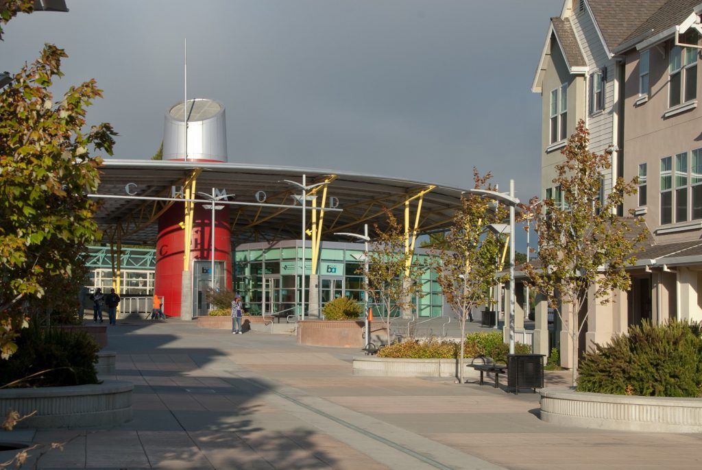
Richmond Plaza
Richmond Intermodal Transit Plaza
Source: https://pgadesign.com/projects/richmond-intermodal-transit-plaza/

Policies/Ordinances that Contributed to Project Success

Richmond Transit Village has successfully transformed underutilized land while promoting transit ridership and home ownership. Despite the increase in the overall production of affordable housing, the City would like to see more affordable units incorporated into market-rate housing projects. To do so, the City amended its Zoning Ordinance to incorporate changes in the State’s housing density bonus law that provides incentives for projects receiving a density bonus.

Outcomes

To date, about 800-900 housing units in the downtown area have been approved, mostly on vacant land, including 200 market rate units, 80 for very low-income seniors (built with reduced parking), plus two projects for 206 affordable units. Another 97-unit for sale project was approved with a 20% inclusionary housing requirement.

The plan will add an estimated 1,240 new transit trips daily and increase pedestrian and bicycle activity, but additional traffic congestion at certain intersections may require mitigation. The plan’s traffic impact analysis was conducted using the LOS (level of service) methodology focusing on automobile traffic and vehicle delay while considering the effect of the transit investments and bike/pedestrian features in the plan on reducing automobile trips.

Challenges and Lessons Learned

At each phase, new guidelines, ordinances and laws have been created to address challenges that arise. Currently, most of the developers elect to pay in-lieu fees as an alternative to providing the affordable units required under the City’s Inclusionary Housing Ordinance. However, the City’s Density Bonus Ordinance does not specify the amount of parking reductions.

As part of the Zoning Ordinance Update, adopted on November 15, 2016, the city evaluated potential incentives. The goal of these incentives was to ensure adequate provision of affordable housing as mandated in Association of Bay Area Governments (ABAG) 2014–2022 Regional Housing Needs Allocation. In their findings, ABAG found that most residents in Richmond are spending more than 30% of their income on rent, which is why the city adopted in-lieu fees and density bonuses into their updated zoning ordinance. The city has “a total need of 2,435 units through the year 2022, out of which just over 29% is for low and moderate-income households and another 18% is for very low and extremely low-income households.”

Another challenge that the city is experiencing is attracting more mixed-use developments. Funding available for market rate financing is very limited, and the city and developers have not qualified for new markets tax credit for developments near the transit village. The plan calls for mixed-use income developments for this major activity center and needs financial support to build it.

San Diego, CA: Reducing Parking in a Transit-Oriented Neighborhood

Overview

Located in the Encanto neighborhood in eastern San Diego, Villa Encantada is the redevelopment of an underused 163-space parking lot owned by Metropolitan Transit System (MTS) adjacent to a trolley station. It is the first implementation of the Southeast San Diego Community Plan, which calls for mixed-use villages next to transit stations in the Encanto neighborhood.

The need for parking replacement was determined through an independent third-party traffic impact analysis and the application of the City of San Diego’s Municipal Code parking requirements. The project developers requested to use the Transit Area Overlay Zone (TAOZ) Parking Rate, which would allow for a reduction of 0.25 parking spaces per residential unit and a reduction of 4.3 parking spaces per 1,000 square feet of commercial floor space.

The Villa Encantada development has 105 residential, 4 commercial, and 100 public MTS parking spaces. This array includes 95 below-grade residential parking spaces, as well as 14 at-grade podium parking spaces shared between the residential and commercial tenants.

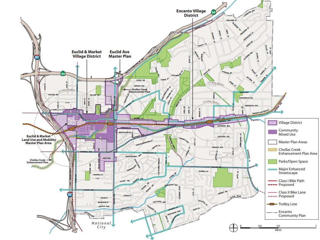
San Diego Transit
Encanto Neighborhoods Community Plan
Source: https://www.sandiego.gov/sites/default/files/legacy
/planning/community/cpu/encanto/pdf/EncantoCommPlanUpdate.pdf

Policies/Ordinances that Contributed to Project Success

The City of San Diego has reduced parking requirements by 25% spaces per dwelling unit for transit areas or very low-income housing areas within multi-family residential developments, and by as much as 70% spaces per 1000 square foot feet for commercial, office, and mixed land uses. Other policy reforms include: allowing tandem parking and shared parking; provision for a payment in-lieu of providing on-site parking; and provision for electric vehicle, bicycle, and motorcycle parking, as well as alternative transportation incentives such as transit passes.

The Community Plan Implementation Overlay Zone (CPIOZ) supports transportation improvements in a “transit priority area”. In the Encanto Neighborhoods, this plan will foster the integration of transit within mixed-use residential and commercial areas, thereby reducing parking demand.

Outcomes

The City of San Diego planning staff have made the following observations about the challenges of the planning and development process:

  • The community was concerned that reduced parking requirements in the neighborhood might cause parking spillover onto their residential streets.
  • Some residents thought that too much mixed-use development would draw more cars to the neighborhood streets.
  • Reducing street level parking lots from 6.3 acres to 0.3 acres was a challenge because parking garages increase development costs.
  • The Encanto Village development has adopted the new mobility plan transit overlay into the parking requirements and has 0.5 parking stalls per residential unit, an important achievement for the City made possible through extensive community outreach and engagement.

Ken Malbrough, community resident and chairman of the Encanto Community Group, has observed that the parking requirements adopted were well-received in the community, partly because transit ridership is high and service is fairly frequent on the trolley line that runs through their neighborhoods. Malbrough also affirmed the importance of community involvement in the planning process to guide growth in a manner that reflects the community’s vision.

icon_resources-orangeAdditional Resources

San Francisco: Transportation Demand Management (TDM) Program

Use of Mandated Targets and Flexible Regulations to Manage Transportation Demand

Overview of Project

The San Francisco Transportation Demand Management (TDM) Program’s primary purpose is to reduce vehicle miles traveled (VMT) generated by new development projects in the City and County of San Francisco. The Program is designed in conjunction with developers and its main intent is to shift travel to and from new developments by providing a series of development-focused TDM measures. Examples of TDM measures include “unbundling” parking from lease costs, providing bicycle parking and amenities, subsidized transit passes, and carshare and vanpool programs.

The San Francisco Planning Code contains definitions for over 100 different land uses. To simplify the applicability of the TDM Program, the TDM Program Standards classify land use code definitions into four land use categories—retail, office, residential, and other. The TDM Program Standards rank the four land use categories from highest to lowest, according to the estimated number of motor vehicle trips per parking space provided for that primary user: visitors and customers, employees, or residents. The online TDM Tool shows the TDM Program elements. These include parking demand management, active transportation facilities and support (bicycling and walking), high occupancy vehicle use incentives (public transit, vanpools), car share, and other measures to reduce private motor vehicle trips.

San Francisco’s TDM Program is regulatory but flexible in nature. The City and County of San Francisco has mandated standards that eligible buildings must meet, but project sponsors or property owners may choose how they meet these requirements. The TDM Program applies to new residential developments with at least 10 dwelling units or bedrooms and new commercial developments that span 10,000 square feet or more.

Policies and Ordinances Contributing to Project Success

The TDM Program Standards are the culmination of years of work and research summarized in the TDM Technical Justification document. In 2014, San Francisco voters passed two funding measures to improve public transit and create safer streets in neighborhoods citywide. San Francisco voters have consistently reaffirmed the city’s transportation planning direction and supported environmentally-friendly transportation options.

Consistent with the City and County Interagency TDM Strategy, the TDM Plan’s effectiveness will be evaluated by tracking changes in solo driving, measured by single occupancy vehicle (SOV) trips. Other indicators of the strategy’s success will include changes in transportation behavior and transportation impacts indicated by other key metrics such as VMT and greenhouse gas emissions. The Resolution in Support of the Transportation Demand Management Resolution provides a clear policy rationale and guidance for implementation.

Challenges and Lessons Learned

In the strong economy of 2017 and 2018, developers have actively participated in the TDM Program since they have an economic incentive to gain timely approval for their projects. City staff report that developers value the flexibility provided in the TDM Program to meet mandated targets in the most feasible way given the specific circumstances of their projects.

As more and more projects come online, the City will gather data and analysis to identify what is most effective and why, determine measures that can be improved, and disseminate best practices. City staff note that direct measurements like the number of bicycle trips caused by specific building plans are often difficult to quantify. Monitoring will depend largely on intercept surveys, whereby researchers stop people as they are coming in and out of specific buildings. Other potential methods include special surveys and journals in which participants record their daily travel. Metrics that will be reported by these measures include reduced motor vehicle trips due to TDM measures, as well as the travel mode share (e.g. drive-alone, transit, bicycle, walking) of the project after full TDM program implementation.

City of San Mateo: Trip Reduction in Transit Neighborhoods

Place-type: Transit Town Center, Mixed-Use Corridor

Overview

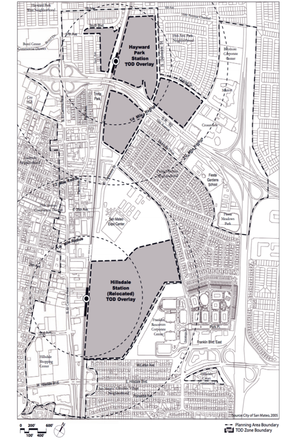
City of San Mateo Transit Map
General Plan Transit-Oriented Development Designations

Adopted in 2005, the City of San Mateo’s Rail Corridor Transit Oriented Development Plan guides the development of an array of land use and transportation projects around two Caltrain commuter rail stations – Hillsdale and Hayward Park. Transportation Demand Management (TDM) measures are integrated into the Rail Corridor Plan for residents and employers to support a 25% motor vehicle trip reduction, even as new development is occurring. To achieve this target, the City of San Mateo Rail Corridor includes TDM measures such as:

  • Parking cash-out programs that give employees a cash payment if they forgo a free parking space
  • Market-rate residential parking charges/prices
  • Transit pass subsidy for employees or residents
  • On-site car-share programs (e.g. Zipcar)
  • Residential permit parking (allows residents to park on the streets in their neighborhood)
  • Preferential high occupancy vehicle (HOV – e.g., vanpool vehicles) parking and carpool promotion and coordination
  • Bicycle parking and commuter facilities (including locker rooms and showers)

The above measures reduce the need for excess car parking, which reduce housing development costs and the impact of new development on traffic congestion.

Policies/Ordinances that Contributed to Project Success

  • The TDM plan has a built-in accountability mechanism to monitor transportation outcomes in new developments. Trip reduction will be measured against available trip generation for traditional projects that do not benefit from the TOD
  • The City of San Mateo’s Below Market Rate (BMR) Inclusionary Program requires developers of new housing to provide a percentage of the affordable units to very low, low, or moderate-income residents for projects of 11 or more units.
  • The Connect San Mateo program, a partnership with Commute.org and SamTrans, offers residents and commuters an interactive and user-friendly website to explore the alternative transportation options available within the City of San Mateo.
  • The City’s zoning code allows for more intense development, with a maximum building height of 55′. That height can be 75′ in designated areas if a public benefit is involved, such as transit supportive policies, mixed land uses, and higher development densities.

Outcomes

The City of San Mateo TDM strategies are in the early stages of implementation. From 2016 to 2017 within the Rail Corridor Plan area, motor vehicle volumes fell by 2%, and pedestrian and bicycle trip volumes increased by 37% and 47%, respectively.

Challenges and Lessons Learned

  • Although the zoning code is flexible and includes development incentives, the small size of parcels and overall height limits may act as disincentives for parties interested in private redevelopment.
  • Employer TDM strategies tend to be the most effective means of reducing peak period automobile trips and promoting transit usage. Trip reduction is more difficult for residential projects because residents may want to own a car even if they do not drive to work every day.
  • The TDM plan identified early on that these requirements needed accountability to be truly successful, leading to the establishment of a process by which projects/developments are responsible for their trip reduction efficacy. The annual monitoring process requires developers or project owners to report annually on how/if the project is meeting the vehicle trips reduction targets.

icon_resources-orangeAdditional Resources

Redwood City Downtown Precise Plan

A Community Remaking Itself

Place-type: Urban Neighborhood, City Center

Overview

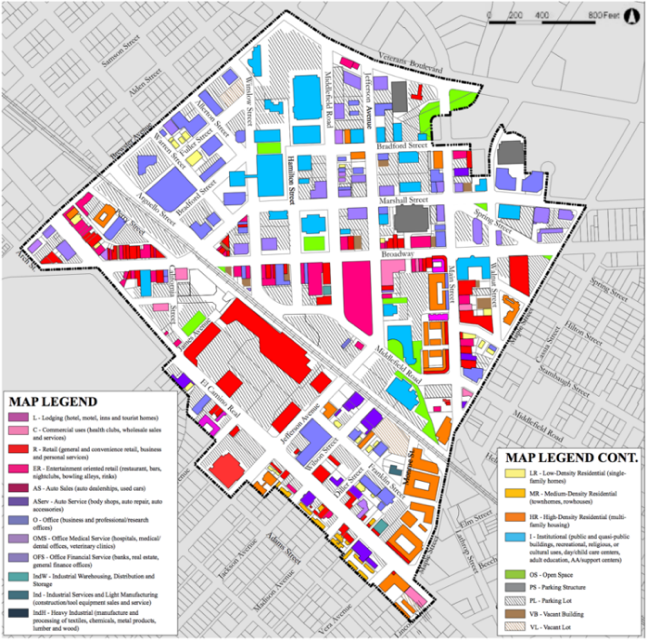
Downtown Redwood City Map
Redwood City Downtown: Existing Land Use Conditions

The Redwood City Downtown Precise Plan (DTPP) was created to revive the heart of Redwood City. It covers 183 acres within the city’s historic center including two historic residential neighborhoods. Most of the DTPP area lies within a quarter-mile radius of the Caltrain station—an ideal size for a walkable district, about a ten-minute walk end-to-end. The Plan acts as a detailed zoning and design code that regulates land use and development within the downtown area. It also guides private and public investment actions in support of downtown growth.

Policies/Ordinances that Contributed to Project Success

  • The DTPP authorizes up to 2,500 additional market rate and 375 affordable housing units for households earning no more than 80 percent of the area median income. The City has adopted policies and programs such as impact fees and incentives to promote the development and preservation of affordable housing.
  • The DTPP adopts a “Complete Streets” approach to street design to meet the need of all users, including bicyclists, public transportation riders, and pedestrians. The plan sets new standards for sidewalk widths, street trees, wayfinding signage and lighting scaled for people rather than cars, to increase pedestrian comfort and safety.
  • The plan encourages the tallest buildings to be placed in the downtown core, and adjacent to the station area while limiting heights around key public open spaces and historic structures to maintain the character of these streets.
  • The city’s progressive parking policy adjusts downtown parking rates by monitoring supply and demand to provide “just enough” parking and creates a “park-once and walk” district to minimize cruising.
  • The Program Environmental Impact Report (Program EIR) assesses the project-level cumulative impacts of the proposed New General Plan. It is more exhaustive than an EIR for a single project and covers future developments.

Outcomes

Recent City-conducted residential housing surveys show an increase in walking, biking, and transit use and less driving alone for all trips. Higher densities, mixing land uses, and investments in multimodal facilities shorten trip length and encourage more non-auto travel options.

Redwood City now has four downtown parking garages with a total of over 2,500 spaces, plus the 160-space Caltrain lot and several smaller surface lots. City reports show that these facilities successfully accommodate current demand for parking. Most offer free parking on evenings and weekends. The City has also installed multi-space “smart meters” for on-street parking, with convenient payment methods, such as credit card or with a remote phone feature.

The DTPP has been supplemented with several new planning initiatives that will further enhance the downtown area and facilitate additional housing construction while managing traffic and parking impacts. RWCmoves, the city’s new transportation plan, provides a framework for a balanced multimodal transportation network addressing the City’s transportation challenges and needs. It offers transit and street corridor improvements, grade separation of the Caltrain tracks, a long-term vision for the downtown transit center and train station, new street connections, complete street corridors, and bike/pedestrian improvements.

Challenges and Lessons Learned

The DTPP took over 20 years to develop through a very thoughtful outreach effort. Despite these efforts, it faced a court battle that forced major revisions just before it was finally adopted in 2010. The Plan has since been amended twice. It has also been a challenge to create more open space for new residents in the fast-growing downtown area and encourage retail activity. Despite the addition of new businesses and residents in downtown, there has been a decrease in retail activity. The city hopes that the completion of all the developments will bring new retail and restaurants to the area.

The success of the Redwood City Downtown Precise Plan shows that urban areas can accommodate additional residential and retail spaces, while careful planning can minimize traffic and parking impact. The Plan’s design guidelines facilitate adequate parking without detracting from the pedestrian character of the street. Since some drivers may be tempted to avoid slower arterial traffic by detouring through adjacent neighborhoods, the City is working to discourage cut-through with traffic calming strategies. Additional parking can be provided as needed and parking demand can be regulated through pricing and new technology.

icon_resources-orangeAdditional Resources

Transform’s GreenTRIP Certification

A Guide to Lower Impact, More Affordable Housing

Place-type: Applicable to all place-types

Overview

The GreenTRIP Program was launched in 2008 by TransForm, a Bay Area non-profit organization that promotes walkable communities with excellent transportation choices. GreenTRIP includes several innovative strategies for the evaluation and certification of housing development projects. It also quantifies the projected impact on the transportation infrastructure and environment. The GreenTRIP includes three main tools: GreenTRIP Connect, GreenTRIP Parking Database, and GreenTRIP Certification.

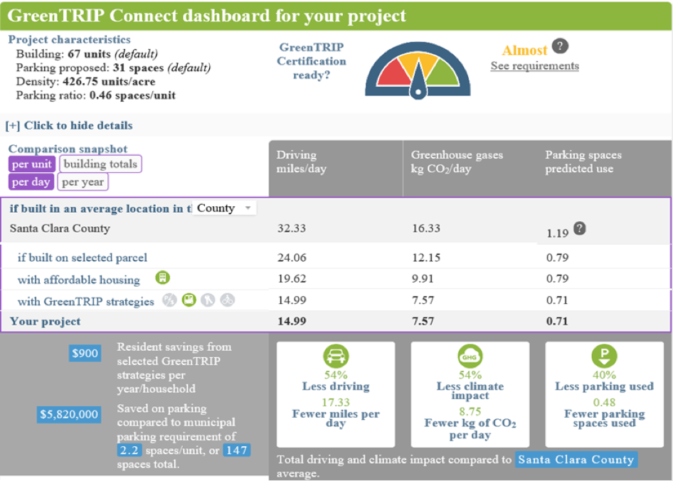
  • GreenTRIP Connect is a calculator with the capability to assess the mobility impacts of development projects. The model compares development parameter inputs, such as the number of housing units and parking spaces, to the underlying parcel-level demographic, employment, and transit data.
  • GreenTRIP Parking Database enables developers to examine whether they can reduce the cost of housing development through innovative parking strategies. The parking database is built to showcase underutilized parking and guide decisions regarding parking supply and management.
  • GreenTRIP Certification, which has been used for more than 25 housing projects in the Bay Area, recognizes developments that meet specific requirements, such as right-sized parking.

    GreenTRIP Connect Dashboard
    GreenTRIP Connect Dashboard

Outcomes

GreenTRIP prioritizes various strategies that reduce automobile dependency. Strategies include site placement that is walkable with shops, stores, schools, and other desirable destinations nearby; availability of safe and convenient transit, bike, and car share services; and transit subsidies provided by developers. The following two projects highlight the challenges and outcomes in applying the GreenTRIP model and GreenTRIP certification process:

    1. Eagle Park Apartments, 1701 West El Camino Real, Mountain View, CA has 67 affordable housing units for veterans and contains 31 parking spaces for residents. Travel demand mitigation measures of the GreenTRIP model applied for this project include:
  • A reduced parking requirement to 0.46 parking spaces per housing unit
  • Free Santa Clara Valley Transportation Authority (VTA) transit passes for all residents
  • At least one bicycle parking space per unit
  • A developer commitment to an annual transportation and parking monitoring survey of project residents

According to GreenTRIP, the approved project is projected to reduce the Vehicle Miles Traveled (VMT) per resident by 26 miles per day compared to the base case without travel demand mitigation measures. The base case, or “business as usual”, did not assume any reduction in zoning code parking requirements, lacked a free car share program, a shared bicycle fleet, on-site bicycle repair, and free transit passes, and did not “unbundle”, or separate, the cost of the housing unit from the cost of the parking required for the unit.

    2. 1450 Sherwin Street, Emeryville, CA is on 8.6 acres of land and includes 500 residential units. Travel demand mitigation measures of the GreenTRIP model applied to this project include:
  • One parking space per unit
  • A free car share program for all residents for 40 years
  • 100% unbundled parking that separates residents’ parking costs from their rental costs
  • A shared bicycle fleet
  • On-site bicycle repair facilities
  • Free AC Transit Easy Passes (AC Transit bus passes) for residents for five years

GreenTRIP analysis estimates that each household will drive 59% less and produce 51% fewer greenhouse gas (GHG) emissions with the transportation demand management measures listed above in place, compared to the “business as usual” base case.

Challenges and Lessons Learned

The challenge for TransForm is to maintain an updated database for travel and demographic data while potentially extending the model to include other states so that GreenTRIP remains useful and can be applied to a wider geographic area over time.

icon_resources-orangeAdditional Resources

  • 1
  • 2
Sign Up for Updates
The latest on Home for All's initiatives, resources, and events.
We respect your privacy.