
Using Translation

The County of San Mateo has added a translation feature developed by Google Translate to assist web visitors in understanding information on this website in a variety of foreign languages. Please be aware that Google Translate, a free third party service which the County does not control, provides automated computer translations that may not give you an exact translation. The County cannot guarantee the accuracy of translations through Google Translate so translations should not be considered exact and only used as a rough guide. Anyone relying on information obtained from Google Translate does so at his or her own risk. The County disclaims and will not accept any liability for damages or losses of any kind caused by the use of the Google Translate feature.

King County: Strategies for Right Sizing Parking

Overview

The King County Right Size Parking (RSP) project, funded by a three-year grant from the Federal Highway Administration’s Value Pricing Pilot Program, assembled local information on multi-family residential parking demand to guide parking supply and management decisions. The objectives of the project were to:

  • Support economic development by reducing barriers to building mixed-use, multi-family residential developments in urban centers near transit;
  • Reduce housing costs as well as household monthly expenditures, allowing a wider market demographic to participate in the urban infill housing market;
  • Encourage transit use, rideshare, bicycling and walking; and
  • Reduce vehicle miles traveled (VMT) and greenhouse gases (GHG) emissions.

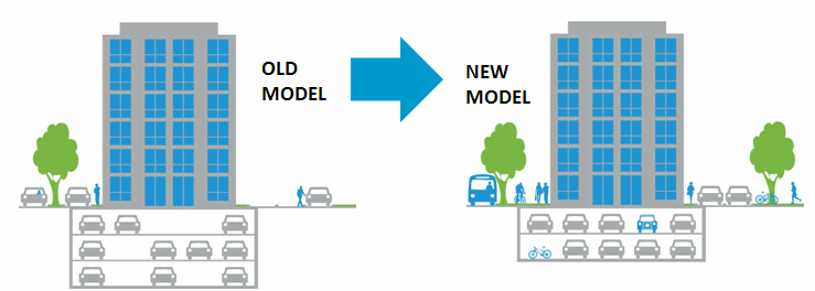
RSP research found on average that more than 40% of parking spaces went unused, often in walkable locations with nearby shops, stores, and restaurants and access to public transit.  The report of research findings noted that construction of parking in multi-family projects costs $20,000 to $40,000 per stall, which impacts rental prices. Based on this research, the RSP Project produced a Technical Policy Memorandum summarizing known barriers and potential solutions for RSP. This included a Right Size Parking Model Code that supports housing affordability and neighborhood walkability based on the RSP Project data and a RSP web-based Calculator which provides context-sensitive information on parking demand. The project also provides resources for developers – a Multi-family Parking Strategies Toolkit to help developers and property managers to better manage parking supply in multifamily buildings, and a Parking Requirements and Utilization Gap Analysis that identified misaligned parking requirements.

King City Model Transformations

RSP Calculator:

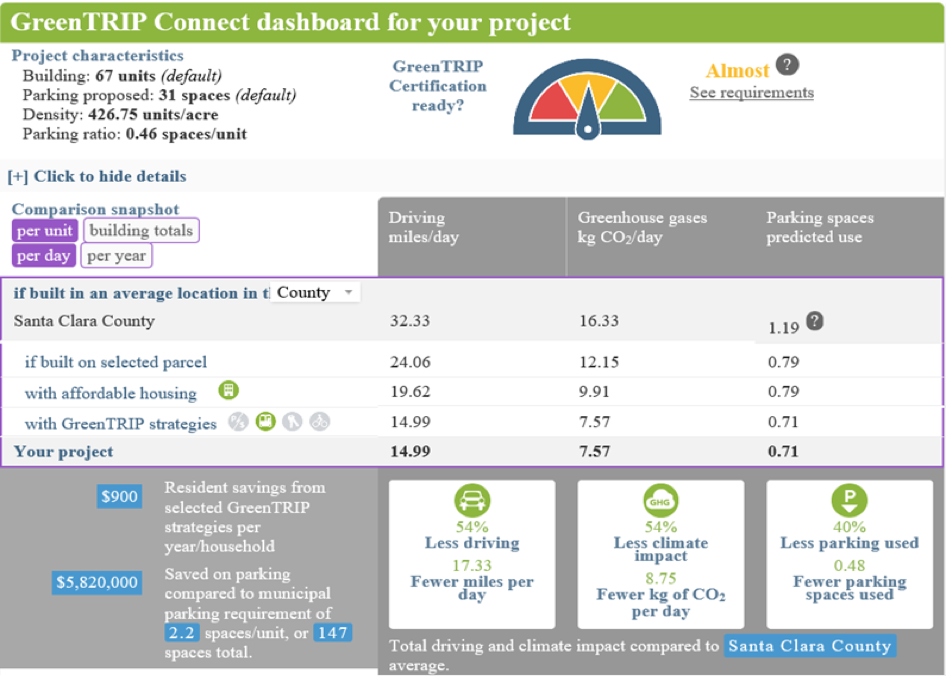
The RSP Calculator was developed by King County Metro, the transportation authority for the County, with support from the Center for Neighborhood Technology and the Urban Land Institute Northwest. It can estimate parking usage for different types of multifamily developments based on building type, location, unit and parking pricing, and proximity to transit and job locations. Additionally, the tool automatically calculates and displays parking utilization estimates for parking pricing bundled with or unbundled from rent, and 100% affordable units or no affordable units.

Parking Model Code:

The RSP Model Code project encourages local jurisdictions to match their parking supply to the actual demand. The model parking code is comprised of two approaches: market-based and context-based. In the market-based approach, there are no minimum parking requirements; rather, the market determines the amount of parking. This approach most effectively matches parking supply with parking demand so that developers are not forced to build more parking than is needed.

With the context-based approach, minimums are set based on the unique context and characteristics of a given project. The process has two steps. First, a generalized place type and associated base parking minimum is assigned. The proposed types are urban core, mixed-use center, and suburban commercial/residential neighborhood. Second, a series of adjustments are applied to that base minimum to account for specific building and contextual features, such as housing unit type, resident characteristics, transportation alternatives, off-street parking management, and parking stall substitutions.

Challenges and Lessons Learned

Having robust, accurate data from the local jurisdiction is crucial to developing the RSP calculator. King County focused on multi-family housing and collected data in the middle of the night from multi-family projects to ensure accuracy. King County has now updated the calculator due to the substantial growth in the county that is seen as continuing and changing land use. The key policy implication from the RSP project is that there is generally an oversupply of parking. Reducing parking requirements encourages greater transit use and enables more frequent transit service.

Despite the data demonstrating that parking is typically overbuilt, localities may still face resistance to reform. For example, the City of Kirkwood faced local opposition when they considered amending their parking requirements. Another challenge is educating developers and lenders about actual parking needs, since many still believe that they must supply additional parking on site in order to market their projects to prospective residents.

San Francisco: Transportation Demand Management (TDM) Program

Use of Mandated Targets and Flexible Regulations to Manage Transportation Demand

Overview of Project

The San Francisco Transportation Demand Management (TDM) Program’s primary purpose is to reduce vehicle miles traveled (VMT) generated by new development projects in the City and County of San Francisco. The Program is designed in conjunction with developers and its main intent is to shift travel to and from new developments by providing a series of development-focused TDM measures. Examples of TDM measures include “unbundling” parking from lease costs, providing bicycle parking and amenities, subsidized transit passes, and carshare and vanpool programs.

The San Francisco Planning Code contains definitions for over 100 different land uses. To simplify the applicability of the TDM Program, the TDM Program Standards classify land use code definitions into four land use categories—retail, office, residential, and other. The TDM Program Standards rank the four land use categories from highest to lowest, according to the estimated number of motor vehicle trips per parking space provided for that primary user: visitors and customers, employees, or residents. The online TDM Tool shows the TDM Program elements. These include parking demand management, active transportation facilities and support (bicycling and walking), high occupancy vehicle use incentives (public transit, vanpools), car share, and other measures to reduce private motor vehicle trips.

San Francisco’s TDM Program is regulatory but flexible in nature. The City and County of San Francisco has mandated standards that eligible buildings must meet, but project sponsors or property owners may choose how they meet these requirements. The TDM Program applies to new residential developments with at least 10 dwelling units or bedrooms and new commercial developments that span 10,000 square feet or more.

Policies and Ordinances Contributing to Project Success

The TDM Program Standards are the culmination of years of work and research summarized in the TDM Technical Justification document. In 2014, San Francisco voters passed two funding measures to improve public transit and create safer streets in neighborhoods citywide. San Francisco voters have consistently reaffirmed the city’s transportation planning direction and supported environmentally-friendly transportation options.

Consistent with the City and County Interagency TDM Strategy, the TDM Plan’s effectiveness will be evaluated by tracking changes in solo driving, measured by single occupancy vehicle (SOV) trips. Other indicators of the strategy’s success will include changes in transportation behavior and transportation impacts indicated by other key metrics such as VMT and greenhouse gas emissions. The Resolution in Support of the Transportation Demand Management Resolution provides a clear policy rationale and guidance for implementation.

Challenges and Lessons Learned

In the strong economy of 2017 and 2018, developers have actively participated in the TDM Program since they have an economic incentive to gain timely approval for their projects. City staff report that developers value the flexibility provided in the TDM Program to meet mandated targets in the most feasible way given the specific circumstances of their projects.

As more and more projects come online, the City will gather data and analysis to identify what is most effective and why, determine measures that can be improved, and disseminate best practices. City staff note that direct measurements like the number of bicycle trips caused by specific building plans are often difficult to quantify. Monitoring will depend largely on intercept surveys, whereby researchers stop people as they are coming in and out of specific buildings. Other potential methods include special surveys and journals in which participants record their daily travel. Metrics that will be reported by these measures include reduced motor vehicle trips due to TDM measures, as well as the travel mode share (e.g. drive-alone, transit, bicycle, walking) of the project after full TDM program implementation.

City of San Mateo: Trip Reduction in Transit Neighborhoods

Place-type: Transit Town Center, Mixed-Use Corridor

Overview

City of San Mateo Transit Map
General Plan Transit-Oriented Development Designations

Adopted in 2005, the City of San Mateo’s Rail Corridor Transit Oriented Development Plan guides the development of an array of land use and transportation projects around two Caltrain commuter rail stations – Hillsdale and Hayward Park. Transportation Demand Management (TDM) measures are integrated into the Rail Corridor Plan for residents and employers to support a 25% motor vehicle trip reduction, even as new development is occurring. To achieve this target, the City of San Mateo Rail Corridor includes TDM measures such as:

  • Parking cash-out programs that give employees a cash payment if they forgo a free parking space
  • Market-rate residential parking charges/prices
  • Transit pass subsidy for employees or residents
  • On-site car-share programs (e.g. Zipcar)
  • Residential permit parking (allows residents to park on the streets in their neighborhood)
  • Preferential high occupancy vehicle (HOV – e.g., vanpool vehicles) parking and carpool promotion and coordination
  • Bicycle parking and commuter facilities (including locker rooms and showers)

The above measures reduce the need for excess car parking, which reduce housing development costs and the impact of new development on traffic congestion.

Policies/Ordinances that Contributed to Project Success

  • The TDM plan has a built-in accountability mechanism to monitor transportation outcomes in new developments. Trip reduction will be measured against available trip generation for traditional projects that do not benefit from the TOD
  • The City of San Mateo’s Below Market Rate (BMR) Inclusionary Program requires developers of new housing to provide a percentage of the affordable units to very low, low, or moderate-income residents for projects of 11 or more units.
  • The Connect San Mateo program, a partnership with Commute.org and SamTrans, offers residents and commuters an interactive and user-friendly website to explore the alternative transportation options available within the City of San Mateo.
  • The City’s zoning code allows for more intense development, with a maximum building height of 55′. That height can be 75′ in designated areas if a public benefit is involved, such as transit supportive policies, mixed land uses, and higher development densities.

Outcomes

The City of San Mateo TDM strategies are in the early stages of implementation. From 2016 to 2017 within the Rail Corridor Plan area, motor vehicle volumes fell by 2%, and pedestrian and bicycle trip volumes increased by 37% and 47%, respectively.

Challenges and Lessons Learned

  • Although the zoning code is flexible and includes development incentives, the small size of parcels and overall height limits may act as disincentives for parties interested in private redevelopment.
  • Employer TDM strategies tend to be the most effective means of reducing peak period automobile trips and promoting transit usage. Trip reduction is more difficult for residential projects because residents may want to own a car even if they do not drive to work every day.
  • The TDM plan identified early on that these requirements needed accountability to be truly successful, leading to the establishment of a process by which projects/developments are responsible for their trip reduction efficacy. The annual monitoring process requires developers or project owners to report annually on how/if the project is meeting the vehicle trips reduction targets.

icon_resources-orangeAdditional Resources

Transform’s GreenTRIP Certification

A Guide to Lower Impact, More Affordable Housing

Place-type: Applicable to all place-types

Overview

The GreenTRIP Program was launched in 2008 by TransForm, a Bay Area non-profit organization that promotes walkable communities with excellent transportation choices. GreenTRIP includes several innovative strategies for the evaluation and certification of housing development projects. It also quantifies the projected impact on the transportation infrastructure and environment. The GreenTRIP includes three main tools: GreenTRIP Connect, GreenTRIP Parking Database, and GreenTRIP Certification.

  • GreenTRIP Connect is a calculator with the capability to assess the mobility impacts of development projects. The model compares development parameter inputs, such as the number of housing units and parking spaces, to the underlying parcel-level demographic, employment, and transit data.
  • GreenTRIP Parking Database enables developers to examine whether they can reduce the cost of housing development through innovative parking strategies. The parking database is built to showcase underutilized parking and guide decisions regarding parking supply and management.
  • GreenTRIP Certification, which has been used for more than 25 housing projects in the Bay Area, recognizes developments that meet specific requirements, such as right-sized parking.

    GreenTRIP Connect Dashboard
    GreenTRIP Connect Dashboard

Outcomes

GreenTRIP prioritizes various strategies that reduce automobile dependency. Strategies include site placement that is walkable with shops, stores, schools, and other desirable destinations nearby; availability of safe and convenient transit, bike, and car share services; and transit subsidies provided by developers. The following two projects highlight the challenges and outcomes in applying the GreenTRIP model and GreenTRIP certification process:

    1. Eagle Park Apartments, 1701 West El Camino Real, Mountain View, CA has 67 affordable housing units for veterans and contains 31 parking spaces for residents. Travel demand mitigation measures of the GreenTRIP model applied for this project include:
  • A reduced parking requirement to 0.46 parking spaces per housing unit
  • Free Santa Clara Valley Transportation Authority (VTA) transit passes for all residents
  • At least one bicycle parking space per unit
  • A developer commitment to an annual transportation and parking monitoring survey of project residents

According to GreenTRIP, the approved project is projected to reduce the Vehicle Miles Traveled (VMT) per resident by 26 miles per day compared to the base case without travel demand mitigation measures. The base case, or “business as usual”, did not assume any reduction in zoning code parking requirements, lacked a free car share program, a shared bicycle fleet, on-site bicycle repair, and free transit passes, and did not “unbundle”, or separate, the cost of the housing unit from the cost of the parking required for the unit.

    2. 1450 Sherwin Street, Emeryville, CA is on 8.6 acres of land and includes 500 residential units. Travel demand mitigation measures of the GreenTRIP model applied to this project include:
  • One parking space per unit
  • A free car share program for all residents for 40 years
  • 100% unbundled parking that separates residents’ parking costs from their rental costs
  • A shared bicycle fleet
  • On-site bicycle repair facilities
  • Free AC Transit Easy Passes (AC Transit bus passes) for residents for five years

GreenTRIP analysis estimates that each household will drive 59% less and produce 51% fewer greenhouse gas (GHG) emissions with the transportation demand management measures listed above in place, compared to the “business as usual” base case.

Challenges and Lessons Learned

The challenge for TransForm is to maintain an updated database for travel and demographic data while potentially extending the model to include other states so that GreenTRIP remains useful and can be applied to a wider geographic area over time.

icon_resources-orangeAdditional Resources

Sign Up for Updates
The latest on Home for All's initiatives, resources, and events.
We respect your privacy.