
Using Translation

The County of San Mateo has added a translation feature developed by Google Translate to assist web visitors in understanding information on this website in a variety of foreign languages. Please be aware that Google Translate, a free third party service which the County does not control, provides automated computer translations that may not give you an exact translation. The County cannot guarantee the accuracy of translations through Google Translate so translations should not be considered exact and only used as a rough guide. Anyone relying on information obtained from Google Translate does so at his or her own risk. The County disclaims and will not accept any liability for damages or losses of any kind caused by the use of the Google Translate feature.

Author: Karen Wang

South San Francisco Station Area Specific Plan

Revitalizing Aging Downtowns, Protecting Neighborhoods, and Connecting Communities

Place-type: Transit Town Center, Mixed-Use Corridor

Overview

South San Francisco Station Map
Station Area Land Use Plan

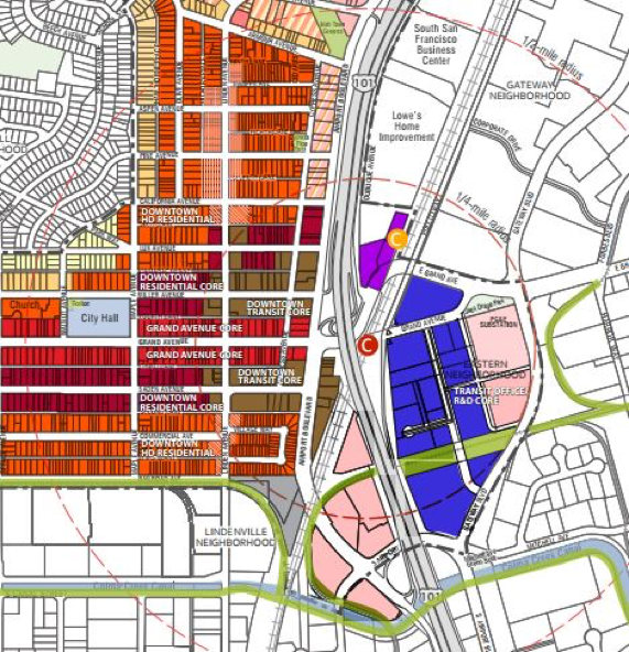
South San Francisco’s award-winning Station Area Specific Plan was adopted in February 2015. Its purpose is to expand the City’s currently obscured and relatively inaccessible Caltrain station and better connect the adjoining downtown area and the emerging biotech areas east of Highway 101. The Plan doubles the number of homes in the downtown, adding about 1,400 units and increases commercial square footage for new office and research and development uses by about 1.2 million square feet.

Policies/Ordinances that Contributed to Project Success

The Plan recommends and encourages several parking practices:

  • Shared parking;
  • Implementation of “in-lieu” parking fees as an incentive to developers;
  • Parking maximums for projects to prevent over building on-site parking where there is an adequate supply of off-site parking;
  • Parking minimums that allow for flexibility for developers who wish to focus on urban, transit-oriented development and support off-site parking;
  • Parking policies allowing residential and some commercial developers to “unbundle” the cost of parking from unit or tenant costs; and
  • Car sharing and ride sharing programs.

Improvements to the downtown area will result in a walkable, bike friendly neighborhood with a variety of housing options. These improvements include conversion of existing angled parking to parallel parking to allow widening of sidewalks and bike lanes. Under the Plan, allowable building heights in both the downtown and eastern neighborhood are greatest near the Caltrain station while heights are reduced in the historic downtown and near existing single family and multi-family neighborhoods.

Outcomes

To date, about 800-900 housing units in the downtown area have been approved, mostly on vacant land, including 200 market rate units, 80 for very low-income seniors (built with reduced parking), plus two projects for 206 affordable units. Another 97-unit for sale project was approved with a 20% inclusionary housing requirement.

The plan will add an estimated 1,240 new transit trips daily and increase pedestrian and bicycle activity, but additional traffic congestion at certain intersections may require mitigation. The plan’s traffic impact analysis was conducted using the LOS (level of service) methodology focusing on automobile traffic and vehicle delay while considering the effect of the transit investments and bike/pedestrian features in the plan on reducing automobile trips.

Challenges and Lessons Learned

In developing the Downtown Station Area Plan, City officials found the key to winning public support was the extensive community outreach they conducted to educate the public about the need for additional housing for the growing number of workers and millennials who prefer urban residences, particularly along transit corridors. It was important to get the public’s input by asking questions such as: “What is important to you?” and “What element do you want to see in the plan?”
The public expressed concerns over three main topics: historic preservation, displacement, and traffic. The Plan emphasizes preserving the unique historic character of Grand Avenue by limiting building heights along the street front for new developments. The Plan also includes programs to mitigate the risk of displacement and preserve existing affordable units.

icon_resources-orangeAdditional Resources

City of Oakland: Transitioning to Vehicle Miles Traveled

Modernizing the Transportation Impact Review Process

Place-type: Urban Neighborhood

Overview

The City of Oakland has adopted a new methodology for traffic management with the goal of minimizing the need for new road and parking capacity and associated impacts on community livability. This methodology will address transportation impacts measured in Vehicle Miles Traveled (VMT) instead of the more conventional model focusing on motor vehicle delay measured in Level of Service (LOS). VMT-focused policy has several benefits. Firstly, it prioritizes mobility (getting people where they need to go) while reducing the number of vehicles miles needed to do so. Compared with LOS’ optimization of speed of travel, VMT works towards reduced emissions from transportation. Secondly, VMT provides a more accurate understanding of land development impacts on highways, public transit systems, and bicycle and pedestrian conditions. Lastly, VMT makes it simpler to calculate and measure regional impacts instead of just local impacts. This methodology will reduce requirements for unnecessarily wide traffic lanes and support more vibrant walkable communities. The VMT approach was created when it became apparent that LOS used in the CEQA guidelines detracted from efforts to create higher quality walkable development.

Policies/Ordinances that Contributed to Success

This policy change is part of a broader array of strategies outlined in The City of Oakland’s newly developed Transportation Strategic Plan. The plan is based on a vision for the city and how the Oakland Department of Transportation serves it in four key areas: equity, safety, sound infrastructure, and responsible governance. The City of Oakland Modernizing Transportation Impact Review Project  and the shift to VMT-oriented policy were enacted in response to the requirements of SB 743.

On April 14, 2017, The City of Oakland issued Transportation Impact Review Guidelines that incorporated guidance on using VMT as a key metric in transportation impact analysis of new land development.  This guidance conforms with the CEQA Update and Technical Advisory issued by the California Governor’s Office of Planning and Research. The City of Oakland considered a variety of metrics in revising its transportation impact review process. VMT was chosen to align with state policy in conjunction with SB 743 and as a robust indicator of the transportation impact of new development.

Outcomes

Cities in California will have until January 2020 to comply with SB 743. Use of VMT as a transportation impact analysis metric will promote the reduction of greenhouse gas emissions, the development of multimodal transportation networks, and a diversity of land uses. The Office of Planning and Research has selected VMT as a replacement measure for LOS not only because it satisfies the explicit goals of SB 743, but also because agencies should already be familiar with this metric. Several cities, including Pasadena and San Francisco, have already implemented the changes.

It is anticipated that this approach will achieve the GHG emission reduction goals; align transportation analysis under CEQA; simplify the land entitlement review process; allow local agencies discretion in implementing circulation systems; and encourage policy trade-offs in dealing with traffic congestion.

Summary of Best Practices, Transportation Impact Review Streamlining

icon_resources-orangeAdditional Resources

East Palo Alto: Ravenswood / 4 Corners TOD Specific Plan

Revitalizing Established Neighborhoods

Place-type: Local Neighborhood, Economically Disadvantaged

Overview

East Palo Alto Revenswood
East Palo Alto Ravenswood/4 Corners Land Use Map
Source: https://www.cityofepa.org/sites/default/files/fileattachments/community_amp_economic_development/page/2811/map.pdf

To address housing and job concerns of residents, the City of East Palo Alto prepared a Ravenswood / 4 Corners Transit Oriented Development (TOD) Specific Plan in 2013 and recently completed its Vista 2035 General Plan Update.

The Ravenswood / 4 Corners TOD Specific Plan promotes compact, mixed-use development with housing concentrated around job centers and along two major transportation corridors: Bay Road and University Avenue. Mixed-use and high-density residential development is encouraged in the Ravenswood and University Corner/Bay Road areas to have a minimum of 25% of land use devoted to housing to create a new downtown. The Plan area is served by two SamTrans bus routes and the Dumbarton Express Shuttle that provides service between Palo Alto and the Union City BART Station.

Policies/Ordinances that Contributed to Project Success

  • The Plan incorporated feedback from existing community organizations and reached out to a wide range of people through 15 public meetings and three interactive public workshops. The City also assembled a Community Advisory Committee that met over a year long period to review the draft Plan and make recommendations to the City.
  • A mix of new employment will be located primarily in the central and southern portions of Ravenswood to help reduce East Palo Alto’s high unemployment rate, which was 19.2% at the time the Plan was being developed.
  • The Plan provides for up to 825 residential units consisting of multifamily development including townhouses, duplexes, four-plexes, and a wide range of multi-family apartments along with some single-family residential development on small lots.
  • A commuter rail transit station is envisioned along a potential future Dumbarton Rail passenger line just north of the Plan Area, which could make office uses more viable and provide better access for current and future East Palo Alto residents. As an alternative, a bus rapid transit (BRT) stop connecting to the East Bay across the Dumbarton Bridge could be developed

Outcomes

The Ravenswood / 4 Corners Plan is a key component of the City’s awarding winning 2016 General Plan Update. It is forecasted to account for about one-third of citywide projected new housing units and retail space, all the proposed new industrial space, and about 60% of proposed new office space. Key transportation policies in the new General Plan include:

    1. (i) a Vision Zero policy, which places safety first and foremost;
    1. (ii) supportive policies and plans for traffic calming, bicycle and pedestrian networks;
    1. (iii) transit-priority streets; new bicycle and pedestrian-friendly street types; and
    1. (iv) reformed performance measures that prioritize safety over roadway widening.

The City is relying on the pedestrian, bicycle, and transit facilities and services outlined in the Ravenswood / 4 Corners Specific Plan to reduce the vehicle trips generated by buildout under the new General Plan. These include closing gaps in the sidewalk network, upgrading pedestrian crossings, new multi-purpose trails, and new traffic signals. The General Plan also includes parking management policies, such as shared parking and residential parking permits designed to alleviate curb parking shortages without relying on excessive minimum parking requirements.
In 2017, the City reached an agreement with the City of Menlo Park to work together to prepare reciprocal traffic studies for projects that may have significant impacts on both cities. The agreement also requires developers to conduct separate housing-needs assessments to address potential residential displacement. This approach is one strategy to jointly address shared issues stemming from regional growth and development.

Challenges and Lessons Learned

Unlike other nearby cities, East Palo Alto’s major concern is generating new employment to address its jobs-housing imbalance. Thus, the City’s planning is focused on attracting new business, while providing new housing choices—both ownership and rental units—for lower-income families experiencing overcrowding.

Another challenge is that although the Specific Plan and the new General Plan support reducing the need for parking, the current lack of direct rail connections within the City makes it harder to justify reducing the city’s already low parking requirements for new developments.

icon_resources-orangeAdditional Resources

  • 1
  • 2
Sign Up for Updates
The latest on Home for All's initiatives, resources, and events.
We respect your privacy.