Transit Oriented Development
Case Study – South San Francisco Station Area Specific Plan
Revitalizing Aging Downtowns, Protecting Neighborhoods, and Connecting Communities
Place-type: Transit Town Center, Mixed-Use Corridor
Overview

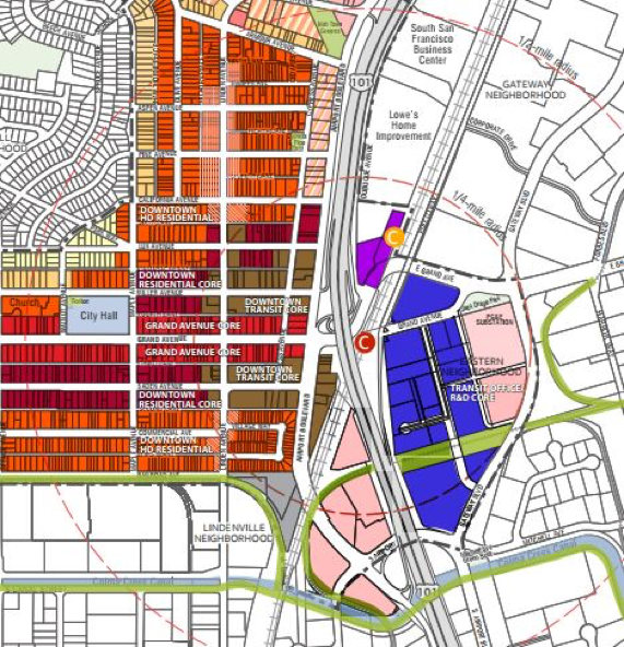
South San Francisco’s award-winning Station Area Specific Plan was adopted in February 2015. Its purpose is to expand the City’s currently obscured and relatively inaccessible Caltrain station and better connect the adjoining downtown area and the emerging biotech areas east of Highway 101. The Plan doubles the number of homes in the downtown, adding about 1,400 units and increases commercial square footage for new office and research and development uses by about 1.2 million square feet.
Policies/Ordinances that Contributed to Project Success
The Plan recommends and encourages several parking practices:
- Shared parking;
- Implementation of “in-lieu” parking fees as an incentive to developers;
- Parking maximums for projects to prevent over building on-site parking where there is an adequate supply of off-site parking;
- Parking minimums that allow for flexibility for developers who wish to focus on urban, transit-oriented development and support off-site parking;
- Parking policies allowing residential and some commercial developers to “unbundle” the cost of parking from unit or tenant costs; and
- Car sharing and ride sharing programs.
Improvements to the downtown area will result in a walkable, bike friendly neighborhood with a variety of housing options. These improvements include conversion of existing angled parking to parallel parking to allow widening of sidewalks and bike lanes. Under the Plan, allowable building heights in both the downtown and eastern neighborhood are greatest near the Caltrain station while heights are reduced in the historic downtown and near existing single family and multi-family neighborhoods.
Outcomes
To date, about 800-900 housing units in the downtown area have been approved, mostly on vacant land, including 200 market rate units, 80 for very low-income seniors (built with reduced parking), plus two projects for 206 affordable units. Another 97-unit for sale project was approved with a 20% inclusionary housing requirement.
The plan will add an estimated 1,240 new transit trips daily and increase pedestrian and bicycle activity, but additional traffic congestion at certain intersections may require mitigation. The plan’s traffic impact analysis was conducted using the LOS (level of service) methodology focusing on automobile traffic and vehicle delay while considering the effect of the transit investments and bike/pedestrian features in the plan on reducing automobile trips.
Challenges and Lessons Learned
In developing the Downtown Station Area Plan, City officials found the key to winning public support was the extensive community outreach they conducted to educate the public about the need for additional housing for the growing number of workers and millennials who prefer urban residences, particularly along transit corridors. It was important to get the public’s input by asking questions such as: “What is important to you?” and “What element do you want to see in the plan?”
The public expressed concerns over three main topics: historic preservation, displacement, and traffic. The Plan emphasizes preserving the unique historic character of Grand Avenue by limiting building heights along the street front for new developments. The Plan also includes programs to mitigate the risk of displacement and preserve existing affordable units.
 Additional Resources
- South San Francisco Downtown Station Area Specific Plan(February 2015).
- South San Francisco Downtown Station Area Specific Plan Environmental Impact ReportVolume I: Draft EIR (October 2014).
- South San Francisco Downtown Station Area Specific Plan Environmental Impact ReportVolume II: Final EIR (December 2014).